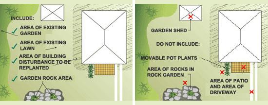
All areas of lawn and garden included in your development must be on your development application plans.
BASIX requires you to enter your total area of lawn and/or garden as measured directly from the development application plans and this is the area in square metres nominated as lawn and/or garden beds, including any areas of indigenous/low water use plant species.
Two methods for measuring landscape area:
- Method 1: for all sites
- Method 2: for all site areas in Water Target Zones 0, 10, 20, 30, and areas >1000m2 in Water Target Zone 40. (Not available for sites < 1000 m² in Water Target Zone 40.)
Method 1
For Landscape Area Method 1, the total area is the entire pervious vegetated area. This includes:
- areas of existing plantings
- areas to be turfed or existing lawn
- area of low-water-use plant species
- areas contained within permanent planter boxes (i.e. planter boxes that cannot be moved)
- irrigated 'vertical gardens' or vegetated walls
- vegetable patches and/or fruit trees
- areas disturbed during the building process, which will be replanted.
Do not include:
- areas of your garden that will be landscaped with hard surfaces (such as rocks in rock gardens)
- vertical areas of vegetated surfaces (e.g. Trellised plants, climbers)
- areas of movable pot plants.

Landscape Area Method 1 - applies for all sites with area < 1000m2 in water target zone 40
Method 2
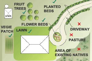
For Landscape Area Method 2, the total area is limited to the formal garden and lawn area. This includes:
- areas of existing plantings
- areas to be turfed or existing lawn that will be actively maintained
- area of low-water-useplant species
- areas contained within permanent planter boxes (i.e. planter boxes that cannot be moved)
- irrigated 'vertical gardens' or vegetated walls
- vegetable patches and/or fruit trees
- areas disturbed during the building process, which will be replanted.

Landscape area Method 2 - applies for all site areas in water target zone 0, 10, 20, 30 as well as sites >1000m2 in target zone 40
Method 2 Excludes the same areas as Method 1, but also:
- areas of naturally existing vegetation
- rural land uses such as pasture or paddock
- Asset Protection Zones (APZ) for bush fire protection
- wastewater/effluent disposal areas, as required by Council, for sites that have onsite sewerage management systems.
In the single dwelling tool if no garden area is nominated for your development BASIX will calculate outdoor water use based on an assumed garden area relative to the size of your site and the footprint of your proposed development.
Landscaped area of dual occupancy and secondary dwelling (granny flats):
Please refer to the apportionment guidelines here to determine the landscaping area associated with the proposed dwelling on a site with an existing dwelling.
Alternatively, if the proposed dwelling on a site with an existing dwelling contains only 1 bedroom, you may specify “0” or a small value as the area of garden and lawn. However, you will need to apply to have this adjustment made to your BASIX project through alternative assessment. Please contact the BASIX helpdesk for more details.